Customers looking to spend a day acclimating, often ask:
“What’s a good day hike”?
The Wind River Range is massive, remote, and mostly known to backpackers doing multi-day trips or long distance hikes. However, the south side of the Wind River Range accessed from Pinedale has amazing public access! The Wilderness area is bordered completely by Forest Service and BLM lands with 10 major trailheads and 3 lodges located almost directly adjacent to trailheads, with several more lodges just down the road. Pinedale is a great place to base out of and day hike the south side of the Winds. Several of the trailheads are not too far from Town making for quick access.
Interactive GOTCO Map of Trailheads, Lodges, and Services
#1 Halfmoon Lake Inlet or #2 Fayette Lake
Trailhead: Halfmoon Lake, ~ 3 miles RT to inlet, 6 miles RT to Fayette
Elevation: 7600ft to 7956 ft (Fayette) +- 356 ft
Hands down my favorite after work hike. It’s close to town, short, flat, and there’s a lake to jump into if you get too hot! From Pine Street, turn north onto Fremont Lake Road by Ridley’s Grocery store, follow this road for about 7 miles, turn right onto FR 743, there’s a big Half Moon Lake Lodge sign, follow this dirt road all the way to the lodge about 2 miles and park. The trailhead is about a 1/4 mile past the lodge, but the road washed out last year, during run-off. The USFS has not fixed it yet, and it is not passable by vehicle, but you can walk past it to the trail (about 30 minutes from Pinedale).
The trail starts out winding through large conifer trees and up a small hill, then opens up into sagebrush and rocky hillside and parallels the lakeshore which is steep and rocky. Follow it around and you will end up at the inlet to the lake after about 1.5 miles, where you can turn around and head back. When you are almost back to the trailhead turn towards the lake before you go up the hill through the conifers, there is small 5-6 foot cliff band you can jump into the refreshing water!!
If you want more, you can cross the narrowest part of the inlet in lower water and continue following the trail another 1.5 miles to Fayette Lake. Sometime ago, someone carried a canoe up there, which they left for the benefit of the public to use and take care of.
Bonus BEERS available at Halfmoon Lake Lodge when open (New owners in 2019! Hurray, we are excited to see what they have in store!)

Beach at Halfmoon Trailhead
#3 Sacred Rim or #4 Photographers Point
Trailhead: Elkhart Park ~ 3 miles RT to Sacred, 10 miles RT to Photographer’s
Elevation: 9300ft to 10,095 feet (Photographers) +- 795ft
From Pine Street, turn north onto Fremont Lake Road by Ridley’s Grocery store, follow this road for about 15 miles, past the Halfmoon turn, past White Pine Ski Area, all the way to the end Park at Pole Creek Trail (about 30 minutes from Pinedale).
Pinedale’s most popular day hike! It is close to town, short, flat, and spectacular! Take the Pole Creek Trail next to the large parking lot and restrooms. The trail is well worn and winds through somewhat thick forest, hike for about a 1/2 mile, there is no sign (bonus points!), but you will see a trail that heads north take and hike another 1/2 miles through a lot of downfall. You will come to 1000ft drop looking down at Long Lake and Fremont Peak, SPECTACULAR! If you want more hike back to the main trail and head east for another 4 miles until you see Eklund and Barbara Lakes, another SPECTACULAR view, and the trail heads north to Titcomb basin, you’ve made it to Photographer’s Point!
Bonus BEERS available at Lakeside Lodge

Sacred Rim looking down at Long Lake
#5 Long Lake Loop
Trailhead: Elkhart Park ~ 5 miles RT to Long Lake 8 miles RT to Loop
Elevation: 9300ft to 8475 ft (Long Lake) +- 825 ft
From Pine Street, turn north onto Fremont Lake Road by Ridley’s Grocery store, follow this road for about 15 miles, past the Halfmoon turn, past White Pine Ski Area, all the way to the end Park at Trail’s End Trailhead (about 30 minutes from Pinedale).
For those looking to get a work-out look no further. Long Lake is close to town, short, STEEP, and spectacular. Once at Elkhart Park, continue past the main parking area, past the campground towards the stock pens, park at this parking lot to access Trails End. The trail heads straight downhill from the parking lot through the forest with switchbacks for about 2.5 miles to the bottom of Pine Creek Canyon. You can go off-piste and check out the lake, turn around and head back up or continue towards Glimpse Lake (FYI wicked steep) around the loop to the back of Fremont Lake then back up!
Bonus BEERS available at Lakeside Lodge
#9 Blueberry Lake
Trailhead: Boulder Lake, 4 miles RT
Elevation: 7300 ft to 8476 ft (Blueberry) +- 1,175 ft
From Pinedale head south on Highway 191 to Boulder 11 miles turn left at the Store onto Highway 353 proceed for 2 miles to the Boulder Lake turnoff, turn left onto County Road 125 follow dirt road for 10 miles to Boulder Lake Campground and Trailhead (about 1 hour from Pinedale).
Take the Ruff Lake trail which you access from the back of the campground, after 1/2 mile or so you will begin a steep uphill ascent the trail will fork turn right and proceed towards Blueberry another 1.5 miles or so.
Bonus BEERS available at Boulder Lake Lodge or head back to the Boulder Store for beers (Boulder Lake Lodge is between managers, not sure it’s open for 2019?)

Boulder Lake Road
#6 Clear Creek Natural Bridge or #7 Fish Bowl Spring or#8 Green River Lake Loop
Trailhead: Green River Lakes, 8 miles RT Clear Creek, 10.5 miles RT to Fish Bowl, 6 miles RT Lake Loop (by itself)
Elevation: 8000 ft to 8400 ft (Clear) 9490 feet (Fish) +- 1,490 ft
From Pinedale head west on Highway 191 6 miles to the Cora Y, turn north onto Highway 352 for ~27 miles the pavement will end at the National Forest Boundary, proceed on the dirt road for ~18 miles to the trailhead (about 1.5 hours from Pinedale).
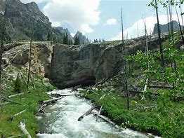
Natural Bridge
A well worn, flat trail with OUTSTANDING views of the lake and Square top mountain. Proceed from the trailhead on the north side of the lake for 2 miles turn north towards Clear Creek, which you parallel for another 2 miles to the bridge. For Fish Bowl head up the Clear Creek trail for a bout 3/4 of mile turn right on the Slide Lake Trail proceed about 2.5 miles to Fish Bowl Springs. Hikers choice; backtrack to the trailhead or if you want more proceed up trail at the Clear Creek intersection head east towards the inlet lake to Green River Lakes. You will come to an intersection cross the Green River and head down the south side of Green River Lake back to the Trailhead.
Bonus BEERS available at Kendall Valley Lodge or The Place (Open in 2019!)
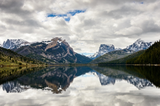
Fall time Green River Lakes looking at Square Top Mountain
